


Winter Is Coming
- christopherevans38
- Dec 11, 2025
- 5 min read

Good evening, Chris Evans here with Zero Meter Chasers.
The well advertised cold pattern is here and we are within 24 hours of our first bigger snow system. First, we will have to deal with some snow showers overnight tonight into Thursday morning. These snow squalls could briefly cover roadways and the heavier squalls could limit visibility with 20-25 MPH wind gusts. Here is the HRRR's thinking on this setup:
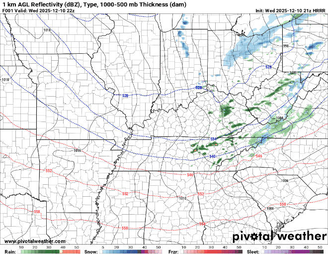
Models typically struggle with seeing NW flow snow showers like these so I think many will see some flakes tonight. Any accumulation will likely be east of I-65 from these squalls and there is a possibility of some travel issues if banding features occur. This would be very isolated though. This system will set the stage for our bigger winter system on Thursday night into Friday.
We already have some winter weather advisories posted by NWS offices as shown below. Would not be surprised to see some areas to the SW of the current advisory added tomorrow morning.

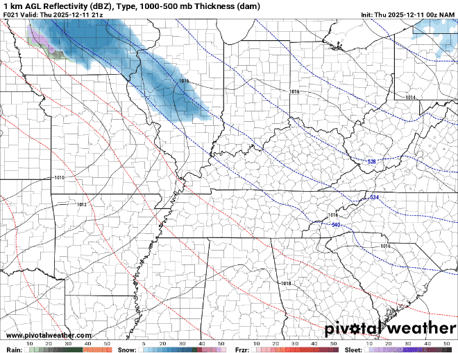
Models have been trending a bit southward with latest data and I have waited to make this blog post until data became a bit more clear. We will start with the HRRR model which was the model farthest northeast with the heavier snow bands for Thursday night into Friday morning. Here is the 0z HRRR run hot off the press

This is still a bit east of some model guidance this evening. Here is the snow accumulation map for this run:

Now let's look at the late night NAM model which has not been the most accurate so far this season.
One thing I think the NAM does have a good handle on is the possibility for some along the WK/BG parkway to transition to RAIN during this event. As the low pressure slides into the region it will bring in a warm south wind allowing some of us to warm into the mid 30s. This warming will also allow for some heavy snowfall with a sharp cutoff on the south side. (sometimes within a couple of miles) This is very common with this type of setup.
Let's look at the NAM snowfall accumulation for this event:

A bit farther west than the HRRR with highest totals just east of Louisville and north of Lexington. This is also a bit of a south shift compared to today's data.
Now lets look at the Canadian, which has been the furthest south and west with our low pressure tomorrow night

One major difference between the Candian and the NAM/HRRR is the track of our low presure. It is much further south and west and weaker allowing for more snow during the onset of the event. This would allow for snowfall a bit further south/west then the current winter weather advisory.
Now with the snow map from the Canadian:

Canadian is showing advisory level snow as far south as Etown and even pushing Winter Storm Warning criteria in Louisville... A remarkable difference and spread between our best models within 48 hours.... As you can tell this is a very complex setup.
Lastly, lets look at the 18z EURO and 12z EURO ensembles (0z is not out yet). The EURO and it's ensembles are showing a similar picture:

18z EURO shown here with our clipper diving in from the northwest and affecting Central and East KY. This would produce a 2-4" snowfall from a line from Louisville to Lexington and points northward. Next lets see what the EURO's ensembles are thinking:

This is looking at the amount of precipitation that falls within a 24 hour timeframe. 0.1 of QPF typically equals 1 inch of snow. Euro ensembles are showing the highest precipitation totals along and just north of a line from Lexington to Louisville
OVERALL THINKING ON THURSDAY NIGHT:
It is quite interesting to see the Canadian and EURO battle the NAM/HRRR. In most cases the EURO/Canadian handles clipper/cold air systems a bit better than the American models. HOWEVER, the NAM can sometimes sniff out a warm nose like it is doing with this system. Every model has it's own flaws and setups that it handles better than others. That is key with a setup like this.
EARLY THURSDAY NIGHT
Snow looks to start around 8-9:00 PM in southern Indiana and Northern Kentucky. I do think most areas will begin this event as ALL snow as the low pressure is still heading toward us. Banding will likely be heaviest on the temperatures gradient so someone within the same county could see heavy snow while someone 10 miles south sees NOTHING. Again. I think many of us start as SNOW late tomorrow night.
OVERNIGHT THURSDAY NIGHT:
Snow will begin to accumulate on a line from Louisville to Lexington. Exact banding features will determine highest amounts but I do think there is potential for someone to see 4-5" of snow from this system in the Bluegrass Region. As the low pressure approaches I-65 I expect areas like Etown to switch over to rain. The exact timing of when this happens will determine if there will be any issues Friday morning along the parkways.
EARLY FRIDAY MORNING:
Snow will begin to taper off a long I-64 and snow bands will be possible in far East and northeast Kentucky. We could see a brief switchover to rain in areas like Shelbyville and Bardstown in the morning as well. This system will be completely out of Kentucky by Friday night.
AMOUNTS:
I want to preface this by saying this map will likely need to be tweaked in the morning. I still don't think the shifting in data is done and honestly I don't like the wide amount of solutions with this setup.... This is our current thinking at Zero Meter Chasers tonight:

Dusting to 1 Inch: Along I-65. There will be a VERY sharp cutoff from the highest snow totals and NOTHING. This looks to divide the I-65 corridor in half. If you are WEST of the I-65, I don't see much in terms of accumulation. East of 65 will see better accumulations and a long I-65 will likely be in the dusting to 1 inch range.
1 to 3 inch: This is including Louisville and Bardstown. Also includes far NE Kentucky. Boom or bust potential in these areas as any slight shift in data will bring in significantly higher or lower totals.
3 to 5 inch: Including the Lexington Metro and just to the north. this is the area with the best potential to see Winter Storm Warning criteria. This banding area can still change but I like where it is for now
LOOKING BEYOND:
I do not want to dive deep into data beyond tomorrow (you can see how well our data is now) but there is another shot for Saturday night into Sunday morning showing up on all the models. Here is the latest Canadian model for SATURDAY night into Sunday....

Brutal cold also showing up early on Sunday morning...

Expect wind chills below zero wherever we have snow on the ground...
This was a jam packed update and I am sure we are not done with updates for our system tomorrow night. I will be up early tomorrow and will adjust snow map as needed. As Jon Snow likes to say, Winter is coming! Have a great night!


Comments