


Active Weather Pattern Incoming
- christopherevans38
- Nov 26, 2025
- 4 min read

Good afternoon everyone! Chris Evans here with Zero Meter Chasers and I wanted to talk about the active weather pattern that is incoming for the Holiday weekend and beyond. It does appear that the pattern is really starting to wake up as we head into early December.
THANKSGIVING DAY:


The good news is we will likely stay DRY during Thanksgiving Day. Some light flurries may be possible in northeast Kentucky near Cincinnati but there will likely be no impacts.
BLACK FRIDAY:

Black Friday will be EXTREMELY cold during the morning with wind chill temperatures in the lower 20s. This will likely be some of the coldest temperatures we have seen all year (so far), so be sure to bundle up if heading out Friday morning!

Here is your simulated radar for Friday, and you can see we will remain DRY and COLD on Friday, and this will set the stage for our next storm system on Saturday.
THANKSGIVING WEEKEND
The arctic air plunge that has already taken over Kentucky is VERY important to the overall pattern as we head into this weekend and beyond. Saturday appears to be the FIRST storm we are going to have to track for potential wintry weather.

As we head into Saturday morning, you can clearly see our system approaching from the northwest... USUALLY, in a setup like this (when you are south of the low-pressure system), it is ALL rain. However, since we will have a cold arctic air mass in place ahead of this system, temperatures are in the mid 20s as the system is arriving....

Not only will we have temperatures that are near or below freezing, but we will also have extremely DRY AIR in the area during the start of our event on Saturday... Dew points will be in the mid-teens

This is important because, at the start of the day on Saturday, we may see "virga" on radar, which is precipitation that does not reach the ground. We will likely experience "wet bulbing" or a drop in temperature until the dew point, and temperatures are very close together, allowing for precipitation. I think we will start Saturday with a QUICK burst of snow for many along and north of the OH River. This is shown well on the latest NAM model:
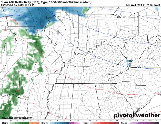
At the beginning of the event, you can see dry air eating away at some of our precipitation. Eventually we will moisten the atmoshere and we will have a quick band of snow approaching I-65.
As the low-pressure tracks farther north of us it will bring in a "warmer" wind, we will likely warm enough to switch over to rain for almost all of KY.
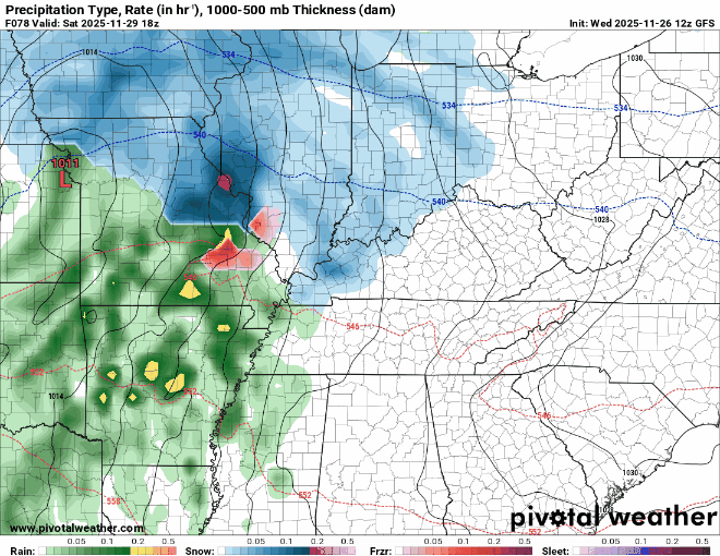
I did want to share the latest GFS and EURO's thinking on this system before moving on to next week. GFS is much weaker, which leads to more of a "thumping" of snow on the frontside before switching over to rain. I do think the GFS progressive bias is showing a bit with this one, but southern Indiana can see light accumulations with this system.

EURO is much more aggressive with the low leading to more warm air advection and rain for KY. The ultimate track of the low will determine how much snow we see with this system. For now, I am thinking any light snow accumulations will likely be washed away by rain during the day Saturday.
NEXT WEEK:
Regardless of whether you see snow or not this weekend, this storm is setting the stage for a potentially bigger storm next week. This system is going to rush cold air in behind it, allowing for temps in the mid-20s on Monday. This cold blast will also cool our road/surface temperatures dramatically.

While we have cold air settling in, another storm system will be getting going out west....

Nearly all the models and their ensembles are showing this system, but all of them differ on the exact track of the cold air (how far south and how strong is the cold air?), and the low pressure is going to take next week...
TUESDAY is the day to watch for this system for Kentucky. Here is the EURO's thinking on this system....

GFS:

Since we are still 6 days out, it is important to look at the pattern and ensembles. Models will continue to change until this storm is sampled.
Lastly, I wanted to share the GFS ensemble members' thinking for our storm next week:

This is all 20 of the 12z GFS ensemble members' forecasts for December 2nd. The good news is that most of the members show a storm in the OH Valley, which is pretty good agreement this far out. But as you can see, there is still a lot to be figured out as we get into next week. One storm at a time! We will be watching!


Comments