


Analyzing The Potential Winter System Next Week
- christopherevans38
- Nov 29, 2025
- 4 min read

An active weather pattern is unfolding across much of the region, bringing a mix of changing conditions and the possibility of a significant winter system next week. We will have a shot today for some wet snowflakes before turning over to rain this afternoon and tonight. After today, all eyes turn to next week as models are showing signals of a system that could lead to an impactful system.
Today's Brief Snow Risk
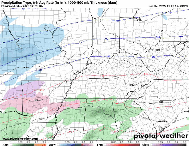
We will have a brief window for possible wet snowflakes this afternoon, especially along the OH River. We will transition over to all rain tonight into Sunday morning with, again, a brief chance to end with some snow flurries. Here is the HRRR's thinking on today:

You can see our low pressure tracking into Illinois and creating travel headaches to our North. As we move through Saturday moisture values will increase and we will have a brief window for some snowflakes along the river. The main snow will stay north of Kentucky into Indiana. Notice as we get into Sunday, cold air makes it way down from the north and there is a brief window for some snow flurries early on Sunday. This cold front sets the stage for our system next week.
Next Week
We have been tracking this system for almost a week now here at Zero Meter and models are finally starting to come to a solution with this system. There are still key variables that need to get figured out to determine where the rain/snow line will setup for our system. Let's start by looking at model data. Here is the 12z GFS (which has been the warmer solution compared to other modeling):

You can see our system approaching from the southwest on Monday. As we get into Monday night and early Tuesday it is important to note that GFS has our low pressure track in the Deep South and that limits the amount of warm air advection ahead of the storm. This allows for a good band of heavier snow to setup along and north of the Bluegrass and Western Kentucky parkways. One thing I have noticed with all models is that this is a very quick system. Precipitation will be completely out of this system by Tuesday night.
Now I want to look at Canadian model which has been pretty consistent on a colder solution with this system the past couple of days:
A couple of major differences on the Canadian vs GFS. First is that the Canadian track our low pressure along the spine of the Appalachian mountains into eastern Kentucky. That track traditionally leads to more freezing rain and sleet and then a band of snow after the low passes to our east. You can also see a low "transfer" with another low pressure pressure in South Carolina. That can dry out our moisture pretty quick as all the energy is transferred to other low. Either way, I do expect a band of snow on the backside of this low for many in Kentucky. As of now, this does not look like a huge event overall but still one that can cause some travel issues.
Last, I wanted to look at the 12z EURO that just rolled out.

The latest EURO continues with the idea of a weaker phasing of our two systems.

Looking at the bigger picture you can see our 2 different waves of energy on the EURO. If these 2 do NOT phase together like the EURO is showing, expect mostly SNOW but LIGHTER amounts for many.
I still think it is too early to talk about potential amounts but I do believe travel impacts are likely Tuesday morning as we will tank temperatures below freezing with whatever precipitation we have on the ground on Tuesday....

There are still multiple model solutions on the table but the BEST area for wintry precipitation looks to be a long and north of the WK/BG Parkways. North of the parkways likely will be all snow. This area can still definitely shift depending on our phase between the 2 waves. I also think its likely EVERYONE sees a changeover sometime early Tuesday morning.
Looking Beyond Next Week
One last thing before I leave. While the focus is on the potential winter system next week, the active pattern may continue afterward. The MJO is a very important driver of our weather pattern here in the OH Valley. The GFS and EURO both are showing our MJO getting into Phase 8 which is traditionally a colder and snowier period for the OH Valley...


I have circled where both the GFS and EURO show us crossing over into phase 8 by December 3rd and stalling in that phase through mid-month.
Colder and snowier times are ahead (hopefully). I will have another blog out early next week as data becomes more clear. This storm will get sampled on Sunday so we should have a pretty good view on it by Sunday night. Bring on the snow!


Comments