


Saturday's Severe Weather Threat Update
- christopherevans38
- Oct 16, 2025
- 6 min read

Good evening! This is Chris Evans or Kentucky_Wx on Twitter and I decided to fire up the blog tonight to update everyone on Saturday's severe weather threat. There has been lots of chatter and we will cover model data showing timing and impacts of storms Saturday afternoon and evening.
We will not be expecting storms on Friday as a high pressure will still be in place allowing for cooler and dry conditions on Friday. The NWS forecast map shows this well.

Saturday has been the day of concern for a couple of days now. There has been lots of chatter on social media about our potential severe threat. Lots of interest in this storm as it is the first weather system we have had in a while with a pretty dead period during most of October.
The SPC has issued a Day 3 slight risk for far Western KY and Southern Illinois as well as Southern Missouri and most of Arkansas. There is also a marginal risk that includes everyone along the I-75 corridor to the west. This includes areas like Lexington, Louisville, Bowling Green and Nashville. This has been slighted expanded in the latest update as timing has been a bit faster on the models today.

One of the main factors creating our severe threat on Saturday is the beginning of an active jet stream pattern. The jet stream (potential wind energy) has stayed well to our north during the last month or so. This allows for less low pressure systems and more high pressure systems aka nice and calm weather. Our jet stream is beginning to dig more into the OH Valley region. This allows for adequate wind energy for storm development. Here is the 12z EURO showing our jet stream dipping into region Saturday night.

Looking at the setup, a cold front will approach the OH valley from the northwest on Saturday. We will warm significantly during the day on Saturday allowing for temperatures in the low to mid 80s for many in the OH Valley ahead of this front. Saturday looks dry until the afternoon for all of Kentucky. Data still has some disagreements on timing of storms during the day Saturday. Some data does have storms pushing into the state around 3-4PM so we still need a day or 2 to nail exact timing of storms. Ahead of the storms will be warm weather Saturday.

Models have been everywhere regarding timing with this system. The high resolution NAM is a bit slower than some of the other model guidance this afternoon. The NAM fires storms in western Arkansas mid-afternoon and a complex of storms will track through the state of Arkansas during Saturday afternoon. This complex will be capable of damaging wind gusts and some large hail, especially in central Arkansas. This particular model does not bring storms into the Kentucky until late overnight on Sunday morning. This is an outlier compared to other model data. Most hi-res model data is faster with the arrival of the line of storms Saturday afternoon/evening.

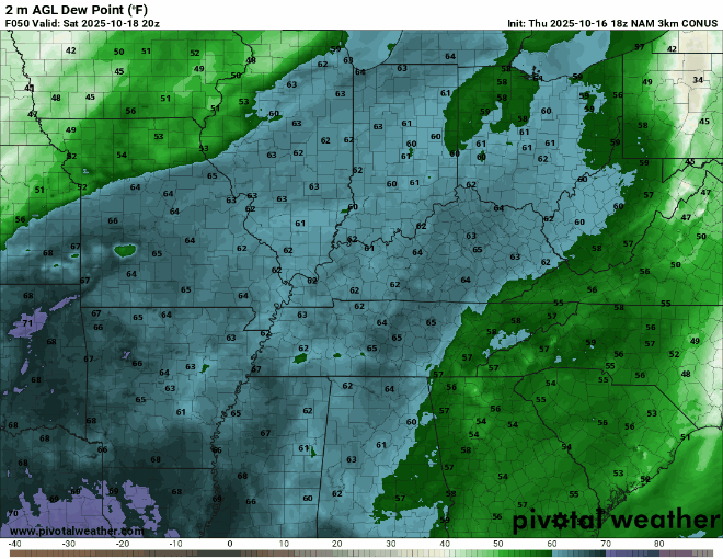
We will have adequate moisture with dew points in the 60s for many areas during this event. There are some differences in exactly where the axis of highest dew points will occur. Here is the NAM showing our dew points during this event. The NAM is more aggressive with dew points in Kentucky compared to some model data. Exact timing of storms will likely affect moisture values. Model data is consistent that mid 60 dew points will fuel this complex in Western and Central Arkansas and Missouri during the afternoon on Saturday.
Very similar to timing, models have varied on the amounts of CAPE or fuel for storms during the afternoon on Saturday. Here is the NAM showing our mixed layer CAPE, or available fuel during this event. Notice how our storms will be feeding off nearly 1,500 - 2,000 CAPE at initiation in Western and Central Arkansas/Missouri. As the sun goes down our CAPE values become nonexistent. CAPE values will be much higher in Arkansas and Missouri compared to Kentucky.

Lastly, storms will have plenty of wind shear to work with. Something I have been noticing is the increasing of the low-level jet as we get into the evening and overnight on Saturday. This is consistent with all of the models this afternoon. This will allow for isolated damaging wind gusts but I think the bigger story may be the non-thunderstorm wind gusts in Kentucky. Winds may gust 30 - 40 MPH as the low level jet goes through our area Saturday night and into Sunday morning.

Now that we have shown the hi-res NAM, I want to look at the EURO model. The EURO has been pretty consistent with this system the last couple of days. EURO also shows our dipping of the jet stream on Saturday. You will also notice the increase of winds into the overnight on Saturday night with the low level jet ripping across the OH valley. Again, expecting some gusty winds regardless of storms overnight on Saturday night.

The EURO is a bit faster with the storm complex during Saturday afternoon pushing the complex of storms into west KY late afternoon and along the I-65 corridor near Midnight. This is similar to other models although some of our hi-res models are moving these storms in a couple of hours faster.

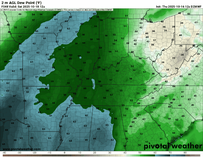
The EURO shows storms firing along mid 60 dew points in Western Arkansas and that is the main reason for the slight risk. The EURO however shows DPs and fuel diminishing as the sun goes down Saturday night. That is a common theme on models and will help limit the severe threat as we lose daylight on Saturday.
Now that I have shown a couple of the models, I wanted to show some of the learning guidance models that have handled severe weather events well in our area in the past. First, is the CSU Learning Model. CSU shows the main risk of severe storms across Arkansas and Missouri. It also shows a broad 15% risk across Illinois and far western Kentucky and Tennessee. This risk aligns well with the slight risk placed by the SPC and the models we looked at above.

Next is the NSSL learning model and it is a bit more aggressive for this event, however the overall messaging is still the same: Storms firing in the afternoon will be strongest in central Arkansas and Missouri.

We are still over 2 days from this event so there is still time for some changes regarding timing. I think the worst severe threat from this event will be the complex of storms during the afternoon hours on Saturday. These storms will be capable of damaging wind gusts and large hail. There will be an isolated tornado threat in western and Central Arkansas. Storms could begin as supercells before forming into a line of storms late afternoon.
Tracking the exact timing of this complex of storms will be vital in determining exact severe risk in Kentucky and Tennessee. A bit earlier timing will bring allow for better fuel with damaging wind gusts as primary threat. This looks most likely in West Kentucky. If timing of storms is after the sun sets (7:30 PM), the severe threat becomes much more isolated with less fuel. Storms will weaken and begin to fade as we get around 11 PM.
Right now I am thinking storms will approach West KY around the 5-7 PM timeframe with storms then approaching the I-65 corridor around 7-9 PM and the I-75 corridor around 9-11PM. This timing is likely to change as model data still has some major discrepancy but I wanted to give some timeframe as it stands now.
Regardless of the severity of storms, thunderstorms look likely Saturday night for those in western and Central Kentucky. All of Kentucky will also see non-thunderstorm wind gusts of 30 - 40 MPH on Saturday night into Sunday as the LLJ rips across the state.
This looks to be the first storm of many as the jet stream is beginning to wake up during Fall severe weather season. We will have full updates on Zero Meter Chaser social media platforms as well as my Twitter account, @Kentucky_Wx. Appreciate all the support and I will likely have another blog update Saturday morning.


Comments